
CONSTITUTION & ADMINISTRATION
The rights base constitution of 1995 established the supremacy of the constitution and the separation of power between the executive, parliament, and the judiciary. The country is administered by government ministries in Capital Hill, Lilongwe and Distrcit Assemblies.
THE LAND
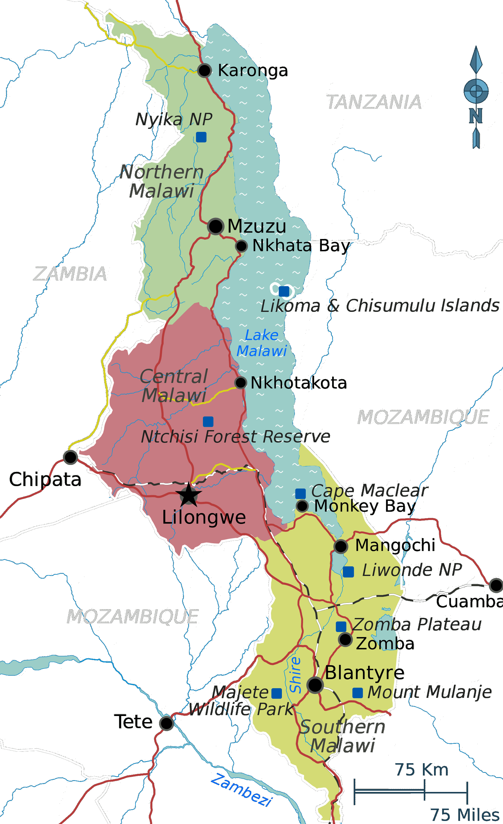
Malawi is a long, narrow country situated in the African Rift between lattudes 9 and 18 degrees south. It is bordered by Mozambique, Zambia and Tanzania. Elevations vary from 30 meters at Nsanje to 3,000 meters at Sapitwa, the peak of Mount Mulanje. Most of the settled towns lie on the Central African plateau at altitudes between 1,000 and 1,500 meters. Lake Malawi, the third largest in africa, is 470 meters above sea level. The lake takes up one fifth of Malawi’s land mass of 118,000 square kilometres. Malawi’s topography displays diversity unusual in such a small African country. The ever-changing scenery, natural vegetation is a mix of miombo woodland, savannah and rain forest. Because of the high population density much of the forests cover has been lost. Prime stands are to be found only in heavily protected areas.
HISTORY
The country, formerly known as Nyasaland (meaning Lakeland), is the result of colonial activity in africa. The boundaries are artificial, cutting through areas without regard to tribal boundaries. Some borders follow natural features while others resulted from trade-offs between the competing colonial powers of Britain, Germany and Portugal. The area came under British influence as a result of the pioneering activities in the mid to late 19th century of David Livingstone and the Scottish missionaries. At the time of their arrival the country was in a state of flux, as the Yao people from the Arab slavers and traders of the east African coast, and the warlike Ngoni from the south moved in. They gained ascendancy over many of the original inhabitants. The British administration brought peace and settled government. The influence of the Arabs came to an end with the execution of mlozi in 1896 in karonga. In the late 1950’s, “winds of change” blew through africa. In 1961, Dr. Hastings Kamuzu Banda became prime minister. Malawi attained self governance on 6th July 1964. In 1966 the country became a republic. Then followed thirty years of dictatorial rule, ending in 1994 with the 1st multi-party democracy, a vibrant media and vociferous non-government (NGO’s) and religious organisations.
POPULATION
Preliminary results of the 2016 census indicates a population of 18 million, the majority of whom belong to tribal groupings such as chewa, Nyanja, Yao, Tumbuka, Lomwe, Ngoni, Tonga, Sena, Ngonde, Lambya. 83% are engaged in agriculture. The urban population is growing rapidly. There are insignificant numbers of Asians and Europeans, although members of the Asian groups are disproportionately represented in commerce and industry. Most Malawian’s profess monotheistic faith. Of the religions mainstream Christianity is the largest in numbers with Islam a significant second. Other minority religions are also practised. Many aspects of traditional beliefs co-exist with the introduced religions and are not seen by their adherents to be in conflict.
LANGUAGE
The official language of Malawi is English. It is widely spoken but not universally so. There are numerous languages which, generally, take their names from the tribes which speak them. The mostly widely understood and spoken of these is Chichewa. The main Chichewa-speaking regions are the centre and much of the south. The north is linguistically very diverse with chitumbuka as the dominant language. Other tribal languages are widely spoken with chiyao spoken by a large minority in the south of the country.
CLIMATE
Malawi has a sub-tropical climate, which is relatively dry and strongly seasonal. The warm wet season stretches from November to April, during which 95% of the annual precipitation takes place. Annual average rainfall varies from 725mm to 2,500mm with Lilongwe having an average of 900mm, Blantyre 1,127mm, Mzuzu 1,289 and zomba 1,433mm. Extreme conditions include the drought that occurred in 1991/92 season and floods of 1988/89 season. The low-lying areas such as the lower shire valley and some localities in Salima and karonga are more vulnerable to floods than higher grounds.
A cool, dry winter season is evident from May to August with mean temperatures varying between 17°c and 27°c, with temperatures falling between 4°c and 10°c. In addition, frost may occur in isolated areas in June and July. A hot, dry season lasts from September to October with average temperatures varying between 25°c and 37°c. Humidity ranges from 50% to 87% for the dryer months of September/October and wetter months of January/February respectively. Light-skinned people should exercise sensible precautions against sunburn and dehydration.
CRIME & SAFETY
The incident of crimes against the person or theft of property is low although most homes in the more affluent areas and virtually all businesses employ security guards. Normal precautions against crime should be taken. There are numerous security companies in the country. The police operate a 990 rapid response services in the cities.
LEGAL SYSTEM
The legal system, civil and criminal, generally follows British law and practice as modified by case law in Malawi and other countries with similar system. There are numerous statutes. Criminal law is codified as is criminal procedure. The 1995 constitution of Malawi with subsequent amendments is the supreme law of the land. No law, person, personage or institution is above law. Laws are made by parliament, approved by the president and overseen by the courts.
| Flag |
 |
| Coat of Arms |
 |
| Capital |
| Lilongwe |
| Language(s) |
| Chichewa English |
| Government |
| Unitary Presidential Republic |
| President |
| Arthur Peter Mutharika |
| Vice-President |
| Saulos Chilima |
| Area |
| 118,484 km2 |
| Population(2016 Estimate) |
| 18,091,575 |
| Currency |
| Kwacha (MWK) |
| Timezone |
| CAT (UTC+2) |
| Dialling Code |
| +265 |
| Internet TLD |
| .MW |